“Roads? Where we’re going , we don’t need roads” – Dr. Emmett Brown, Back to the Future
With the likelihood that the fuel crisis will be with us for some time, lets go back to the future and look at alternative transport options.
There are good reasons to leave the car at home. Not just the cost of fuel. Vandalism, theft, fuel syphoning, being environmentally responsible, peace of mind to name a few.
But what is possible and what is practical are two very different things for different people.
So lets start in our own back yard and look at the Heysen Trail from the point of view of solo or small group travel. I have not included links or timetables as these are easily found online.
Hiking the Heysen Trail Using Public Transport
My grandson and I have hiked from Cape Jervis to Mount Lofty on the Heysen, starting and finishing using exclusively cheap and convenient public transport [Bus or train and bus]
From Cape Jervis to Victor
To Cape Jervis via K.I. Ferry connection bus run by either Sealink or Link SA. Return from Victor by Link SA bus, linking to Seaford train line to Brighton where I live. Or go all the way into the city.
Victor to Mt Compass & Mt. Compass to Crafers
To Victor Harbor by bus [Link SA, several daily connections]. Then Heysen trail to Myponga or Mount Compass. Return by K.I. bus from Myponga or via the Victor Harbor bus from Mt. Compass.
Adelaide Hills Heysen Trail
Connections with the Adelaide Metro bus network are shown here.
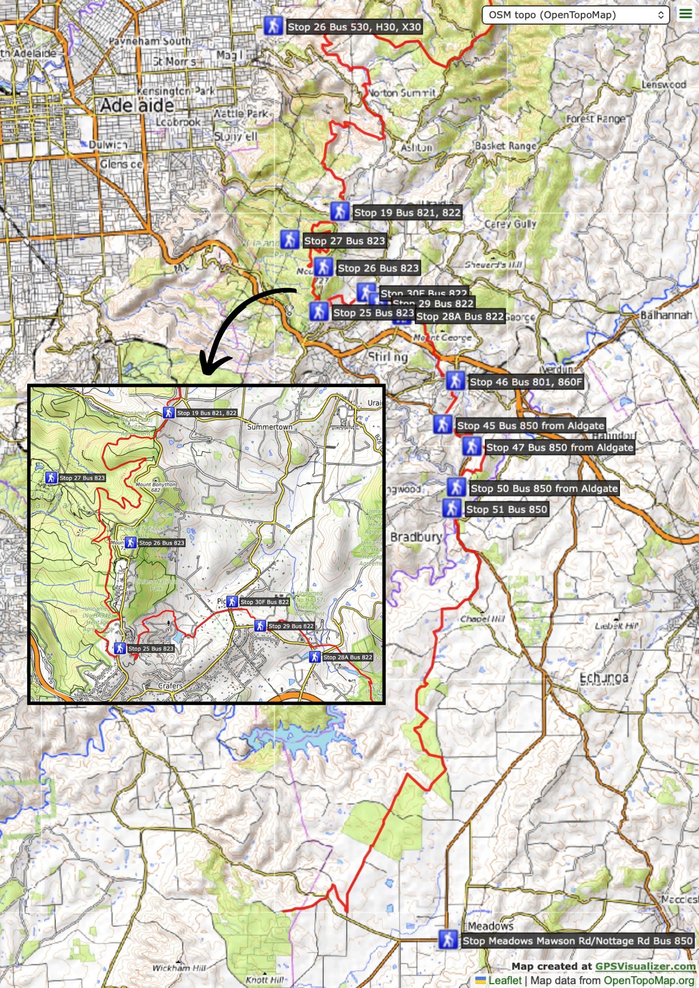
To Crafers interchange by metro bus either from the city or Blackwood. Join the Trail at Woodhouse Scout camp then walk to Mount Compass or north to Tanunda.
After that it gets a bit more challenging and requires a little more planning and commitment.
Crafers Bus Interchange to Tanunda. Best to study the official trail notes as accommodation options are a bit poor for a section of the Heysen so close to the city.
Bus back to Adelaide from Tanunda via Link SA or continue to Burra. Link SA buses also intersect with the Heysen route at Cudlee Creek and Chain of Ponds.
Mid North Heysen Trail
Yorkes and Lower North Bus stops at Burra and Hallett (one day a week) and Spalding (2 days a week). So planning longer sections in the mid north is possible but requires a bit more commitment. The Spalding hotel is a great spot to send resupplies, and rest.
The Stateliner bus to Port Augusta stops in Crystal Brook on most days of the week twice in both directions and can stop at Mambray turn off by arrangement. This makes Mt Remarkable NP accessible. You could easily spend six or seven days there or walk through to Melrose for resupply before heading south to Crystal Brook for the trip home.
Crystal Brook is also on the Heysen trail. The sections between Melrose and Crystal Brook and Burra are doable, if you are willing to stay out on the trail longer and can carry the extra days supplies. Crystal Brook to Melrose takes four days, the middle two in bush following the range. As for going south I don’t understand why anyone would find walking past endless bloody sheep paddocks interesting. But each to their own.
Editor’s note: one reason may be the number of resupply options! One day gets you to Georgetown, another two or three to Spalding, and another two to Hallett, each of which has general store and accommodation options, and the latter two buses back to Adelaide. Then, however it’s then a long stretch to Burra.
This just about covers the sections of the Heysen that are reasonably practical for small groups or individuals to access by public transport.
Further north it gets a bit difficult for logistics. For some, a viable alternative might be to bus to Port Augusta where Angorichina Village does a weekly run on Wednesdays up to the Heysen trail head in Parachilna gorge via Quorn, Hawker, Wilpena, Blinman. Cost is $175pp. Ph.08 86484842, email: ango1@westnet.com.au. By reports, the country is looking magnificent at the moment.
This page contains an interactive map of regional bus services in South Australia.
The South East
There is a Stateliner bus that travels along the Coorong. I don’t know the best start points for walks there. ABW regularly offers a walk from Salt Creek that utilises the local trails and 42 Mile campground for example.
K.I.
Easy enough to get to K.I. by Sealink bus and ferry and once there a local company runs minibus transfers to Flinders Chase and elsewhere.
Interstate
Gariwerd [Grampians]
So far I have not had success convincing a Bus company to stop half way between Horsham and Stawell. But that might change.
This would make the Northern edge of Gariwerd near Mt Zero accessible for a pleasant walk through to Halls Gap. From or to Halls Gap there is a regular V line bus service to Stawell.
From Halls Gap walk to Dunkeld along southern Gariwerd ranges. From there a local transfer company can return to Halls or walk back to Halls via a somewhat circuitous route initially past a lot of farm land to the west and north of Dunkeld. I have not done this, but the first 20 ks look a bit boring.
Alternatively as Dunkeld is on the bus route to Mount Gambier, a bus to Adelaide leaves the next day. Unfortunately the timetables do not coordinate. But an evening in Mt Gambier is not a hardship.
Beyond those places listed above, connections get a bit too time consuming for practical use.
Comments (0)