The River Murray is the 15th longest river in the world (2,520 kilometres) and the 3rd longest navigable river – 2,224 kms from the bottom of the Hume Dam to Goolwa – but in fact a kayak or other (very) shallow vessel is capable of starting from Bigarra located between Khancoban in New South Wales and Corryong, Victoria, thereby adding some 200 kms to this figure. While still 100 kilometres from its true source, this part of the “river” is not navigable because it is little more than a stream over rocks.
Having heard on ABC radio a couple of years ago someone suggesting that the Murray is one of the last wild, in the sense of undeveloped, rivers left in the world I was keen to paddle from its source to the sea. In September, 2012, I paddled the 1410 kms from Swan Hill to Goolwa and was keen to complete the journey.
Early in the November just gone, my wife and her sister drove me to Biggara and at noon on the3rd of that month I dropped my faithful kayak, Tui, into the River Murray and headed off on the second leg of my journey. I had learned from www.mdba.gov.au/river-data/live-river-data there were sufficient water flows for the journey and that the water was 23 degrees.
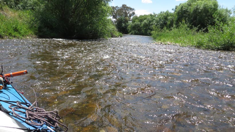
At Biggara the Murray is the width of a suburban street, is about 300 millimetres deep and the first stretch is lined with willows. I had done the section from Biggara to Bringenbrong Bridge before, in October last year on a reconnaissance trip, when there was a great deal of water running in it and it was exhilarating to say the least. Then no paddling was required but rather I had to concentrate on resisting the river wanting to drive my (then) empty Tui into the willows on the bends. On that occasion I averaged 12 kph. What would it be like this time with a fully loaded kayak?
Without the snow melt, the ride down was much more sedate than previously but still great fun. Some paddling was required but not too much. At one point, about 4 kms down, I had to portage Tui because a willow had fallen blocking the whole river. Fortunately I had a trolley (to get me around the Hume Dam and Yarrawonga Weir) but I didn’t think it would be required so early. When I finished this section, I rang my wife and told her I had covered the most dubious/dangerous part and she was free to head home. Little did I realise, I was now on my own!
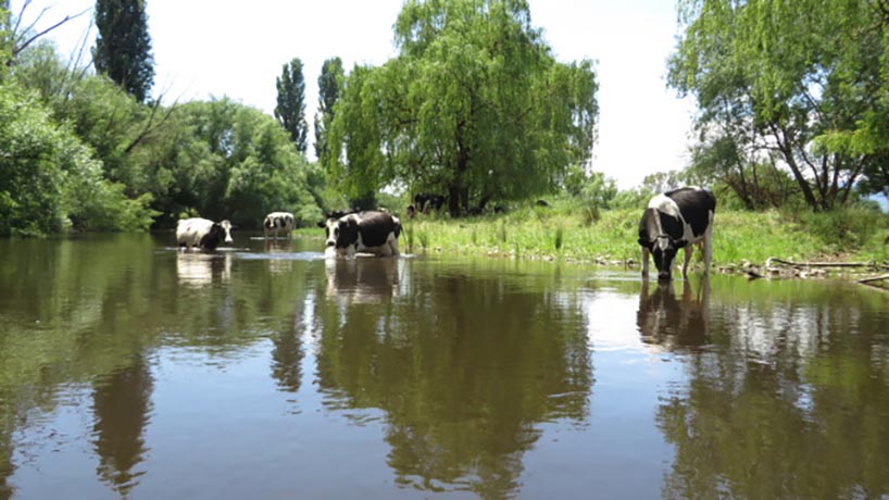
Although there are very good maps from Yarrawonga to Goolwa which show every twist and turn of the river, there are no easily accessible detailed maps of the area above that. Consequently I only had some basic Google maps of the river. For that reason and because there are no markers above the Hume Dam I had no exact idea of how far I travelled that first afternoon. Given the current, though, I suspect it was about 50 kms. The paddle took me through lush beef grazing country – the animals were frequently in the river itself – surrounded by mountains.
While the land in NSW is privately owned to the water’s edge, in Victoria the first 60 metres is Crown Reserve and anyone is free to camp there, a fantastic legacy to the people of Australia from the founding fathers. Despite this, on the first night I camped on the NSW side just north of Towong.
The next morning I set off at about 0800 hrs. The scenery was gobsmackingly beautiful. In fact it was so beautifully that a couple of times I ran into snags on the banks as it was all I could do to take my eyes off the country I was passing through. Little did I realise that a real life adventure was just around the corner. I came to a T section with the water to the left and right of a junction. I stayed in the middle of the river so I could choose which way to go. Mistake. As I approached the junction, Tui suddenly shot forward straight into the pile of debris which had accumulated on the opposite bank of the junction. My efforts to turn to the left came to nought. I was pinned to the bank unable, because of the strength of the water to move forward or backward. As I wondered what I was going to do I felt Tui began to tilt. The water was driving her under the flotsam. A point came when I realised I was going to be flipped. I grabbed a mouthful of air and over we went. I recall having time to think this was not good, snags everywhere, a fully loaded kayak upside down and I could die here and no one would know.
I slipped out of the cockpit and ended up next to my overturned kayak. I had Tui in one hand and my paddle in the other (although it was tied onto the boat – but how much pressure could the strap sustain before it was torn loose?). I eventually worked Tui to the right but, with no bank to beach her on, I managed to climb up on a platform of debris still holding both kayak and paddle and begin the mopping up operations.
I flipped Tui the right way up and managed to partly haul it onto the debris and used one of my water containers to bail out the water. I checked the damage. I had lost a kayak shoe and a seat I kept in the bottom of Tui. My SPOT and my Epirb were also gone. The rest of the day was somewhat sobering as I recalled the morning’s misadventure and realised that having lost my SPOT I would have to rely solely on my mobile if I needed help.
There were rapids, of a sort, in the river where the water level suddenly dropped which required me to (instantly) assess the best course and not prevaricate. Despite the fact that they roared ahead of and at me, they were all noise. Just a bit of fun.
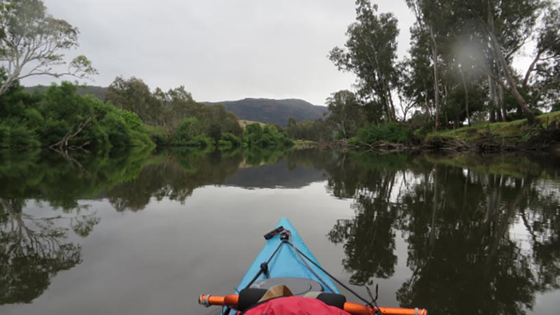
Although physics tells me that water finds its own level, the remarkable part of this exquisitely beautiful part of the Murray was wondering how it found its way through the mountains which surrounded me on all sides. Just when I thought there was nowhere left for the river to go; it would bend around a hill and head down another valley. Then, faced with yet another wall of mountains, it would again change direction to find a valley between two hills. Of course the good thing about paddling is you never get lost … well almost never!
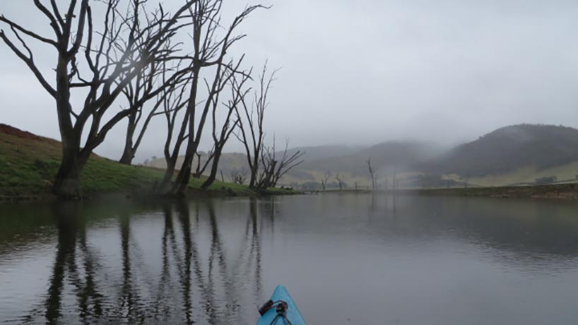
On the third day the river took us to the beginning of the Hume Dam. On paper I thought I could simply paddle in a straight line but given the dam was only about 60% full, of course this was not the case. I followed the river slowly sinking deeper and deeper into the dead tree lined water course until at last I came to a point where water spilled over the river bank. I could see where the original Murray went by the dead trees standing up and out of the water but I could cut across it to the next bend. This part of the river was both sad (because the river and its red gum sentinels had been trashed) and also very revealing because of the bird life, particularly the pelicans and the swans. Both of these birds are very majestic in the water and more particularly when they take off. The pelicans simply unfold their wings and with one flap have their bodies in the air while the swans have to run across the water in a rather clumsy manner until they clear the water when, with exotic white under-wings contrasting against their otherwise black feathers and their necks stretched out ahead of their bodies, they are the most elegant birds. What must the first Europeans, used to white swans, have thought of them?
When paddling on a river one always has a sense of moving because the proximity with the bank reinforces that it is so but in still water, on large expanses of it with no current to assist, that sense of progress is easily lost. So it was on the Hume Dam. I seemed to paddle for hours and get nowhere. It was also on two legs of the Hume that I was embraced by Nature and given a real treat. The dam itself is in excess of 30 kilometres long which means that at a speed of about 5 kph, it will take 6 hours to paddle. I had covered about 75% of this distance, there was not a breath of wind, dark grey clouds accentuated the colours and the starkness of the landscape and occasionally some raindrops punctured the water. I was into a 6 kilometre leg across virtually open water when the rain came, about twenty millimetres in 45 minutes (I learned afterwards)!
Imagine a kayak sitting on grey silk. When the first raindrops hit the water, they create minute black dots in the silk. But when heavy rain hits, each drop creates a small hole surrounded by a cone made up of water droplets propelled into the air by the sheer force and size of the raindrop. The bow wave, the only indication of progress through the water, disappears. Now roll in the mist to obscure everything in every direction leaving a white haze of dancing water droplets on the horizon. Turn on the lightning and thunder. You paddle but nothing changes. You seem not to move. There is nowhere to hide or seek shelter. You paddle solely by maintaining your compass bearing. Every few minutes the sky lights up and some (fortunately long) period later (ten seconds?) a boom crosses the water in surround sound. There are only you, the kayak, the compass, the grey surface of water alive with activity and the rain. This is your world. Nothing else exists. You are not frightened. You are certainly wet but you are not cold. You don’t want it to end. It feels like it won’t for you don’t seem to be moving at all. Time is meaningless.
You think you see a dead tree on your bearing. Slowly it becomes more than a hint. You set it as your new marker. You paddle, seemingly endlessly, towards it. It gets bigger, clearer. You see another tree behind it. The mist lifts. Everything is clear and clean. You are still a kilometre from the bank. But where are you? Nothing looks familiar? How could it? The landscape has been gone for thirty minutes. How does it reconcile with the map in front of you? You have no choice but to trust in your bearing. You paddle on. Now you see the headland. You are where you should be. You have just experienced a unique insight into Nature. You are on a natural high.
In fact I slept on the shores of the lake that night, four kilometres short of the dam wall. Next morning, I portaged Tui to the river beyond and re-commenced the paddle. Albury was 28 kms away, about three hours. It was a place to resupply.
Below Albury we were again on the Murray when we saw the first of the blue and white signs indicating the number of kilometres to the Murray Mouth. It read 2224.We knew that Swan Hill was at the 1410 mark so it was only 814 kilometres to go. All was well in my world. We had survived the unknown.
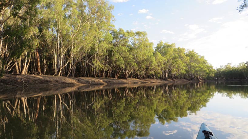
We had the river to ourselves again. Technically, I should stay to the right hand side of the river but, apart from a few campers on the Victorian side of the river, there is no one around. I call it “my river” when I can paddle on whichever side I like, when I can wander from one side to the other because there are no towns or people or boats. It is a wild river and it is “my river”!
The 240 kms section below the Hume was significantly different. Gone were the mountains and even the hills. The river had widened out a little but was still pretty compact. On one stretch of particularly meandering river, many red gums had fallen into the water making it virtually impossible for any but a small craft to pass. At other places, and this was common all the way down to Swan Hill, various strategies had been employed to try and prevent or mitigate the erosion of the river banks. In some places granite rocks had been dumped inside the bends, at others wooden piles had been driven into the bottom of banks to break the flow of the destructive water, at others wooden posts had been driven into the ground and backfilled with sawn logs. I couldn’t help but think that at the end of the day the water would do as it wants to.
There were some beautiful beaches on the way through and the Victorian riverbank, in particular, was often dotted with campers in tents, caravans and camping trailers. And what a holiday they would have. Watching the river flow, as my friend Bob Dylan says.
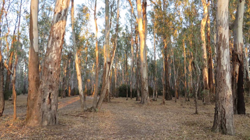
Further down there were also areas of forests of red gum, that tree so intrinsic to the Murray.
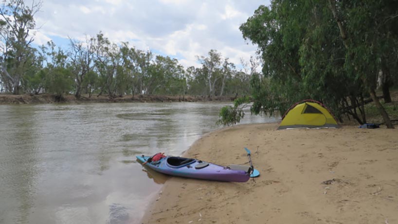
The depth of the banks of the Murray ranged from 300 millimetres to 4 metres. When the banks were high, “beaches” were my best friends. These were protrusions into the river, normally behind a bend where the current was very slow and where red sand sediment had been deposited over the millennia making them firm underfoot. Many of these had red gums, both old and new, providing
shade and were as good as a beach on the coast, perfect places to stop for a break, for lunch or just to strip off and jump into the water to cool off. Where there were no beaches I had to land on mud where my feet sank into the red mud, sometimes with stinking grey soil underneath. Where this occurred mosquitoes awaited me on shore. Not good. Generally speaking, though, there were few flies or mosquitoes and certainly not when I was on the river paddling. This made a good reason to keep to the water in those situations.
The river took me into the particularly lush beginning of the 20 km long Lake Mulwala where the tourist settlement of Bundalong stood. While I tried to follow the Murray using the live trees as my markers, I eventually lost the trail. Unable to see the shores of the dam because of the heavy stands of live and then dead trees, I again had to use a compass bearing to find my way to the weir. Again the water was like silk though this time it was light blue through which dead red gums protruded, both in the original river and the surrounding expanses of water.
The next morning as I portaged around the weir, I learned that each year there was a Victorian River Marathon, a 404 km paddle which takes 5 days which was due to leave soon. I had been doing somewhere between 50 and 70 kms a day but calculated that if I did 50 kms a day, I would finish my paddle on a Saturday and my family could pick me on a weekend. Any faster than that and I would be stranded in Swan Hill. I wondered if I was going to get run over by these marathon paddlers.
Below the weir, I set off on a narrower river which took me past some magnificent beaches, many of which on the Victorian side were packed with campers. I passed through the lovely town of Tocumwal before entering the 100 km long red gum forests of Millewa and Barmah on the NSW side and Moira on the Victorian side. There was some amazingly beautiful country here with river banks only 300 millimetres high in places. In times of flood, water spills over the banks and floods the surrounding lowlands supplying water to the forests. It was in here that I hit the Narrows, a place where the river shrinks down to a twenty metre width and where the water fairly races along. The forests here were very lush and the bird life phenomenal.
In the mornings, I was woken by an extremely raucous dawn chorus about 5.30 am, an hour before sunrise. I can report that generally the kookaburras were the first birds to announce the coming morning followed by either sulphur crested cockatoos, corellas and/or magpies. Once these were done, it was open slather with birds of every type having their say. I had heard a program on birds that reported that birds have different calls and pitches so they can all hear each other at the same time, that is to say they fill the entire sound spectrum from low frequency to high. How true it was. The decibel rating of these choruses was astounding. Nothing quiet about it.
And speaking of birds, early on I witnessed a murder. I didn’t see it but I certainly heard it, a murder of crows (ravens, actually). There were about 100 of them, it was like Federal Parliament at Question Time with each one trying to speak/sing/squawk at once and did it sound murderous. My son later told me it was probably caused by a dead crow as they do gather over a fallen comrade. http://news.nationalgeographic.com/2015/10/151003-animals-science-crows-birds-culture-brains/.
I pushed on to the town of Barmah. While most of the days were great weather, 25 to 30 degrees, on this day it was pretty warm so I hung around until late afternoon before setting out again to put some space between me and the town. I had found on my last trip that the last place I wanted to be at night was in a settlement.
Depending on the weather and how far I was paddling, I would set up my tent late afternoon, gather firewood, write up my diary, have a wash and cook dinner often to the sound of the birds as they signed off for the night. They were often as noisy at this time of day as they had been in the mornings. Once I had finished my meal, I would retire to my tent just before dark, read for a bit or maybe listen to a few songs on my iPod. When I woke up with my light still on or my earphones still in, I would turn it off and drift back to sleep. Although I woke, often caused in the first two weeks by tingling fingers as a result of gripping the paddle for hours on end, I fell asleep.
It was Sunday as I approached Echuca and I came across a paraplegic and his party who was doing a reconnaissance for a trip he planned kayaking from the source of the Murray to the sea. His kayak was fitted with two outriggers and he had a support team consisting of a mate, an able bodied fellow kayaker, and another driving a powerboat towing a tinnie loaded with his wheelchair and supplies. The other kayaker explained that when he actually did the trip, different mates would accompany him on different sections. Now that’s gutsy.
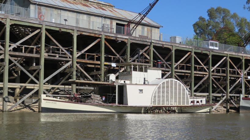
Echuca was once the busiest inland port in Australia as paddle steamers plied the river taking supplies to farms, and returning with farming produce to the Echuca railhead to Melbourne. For those who haven’t been to this tourist town, the docks have been restored where working paddle steamers are moored and along the banks. I had kayaked this area before but that did not diminish the impact of rounding the bend to see the port of Echuca and its vessels. It was not hard to imagine I was in the middle of the nineteenth century when the town was in its heyday.
I re-supplied and headed out but not before learning that the previous day the river south of Echuca had been closed for the 2015 Barrie Beehag Ski Race during which boats and skiers reach speeds of up to 180 kph. While I thankfully missed that, all the snags from Deep Creek Marina to the Torrumbarry Weir, the first lock on the Murray, were unnaturally decorated with bright orange flags, plastic bottles and containers. In this section, the river was very wide, and slow, with beautiful large areas of flood plains and lagoons particularly near the weir. After the Torrumbarry Weir the orange flags ended as I entered a narrower and fairly remote part of the river which essentially ran through 100 kms of red gum forests on both sides of the river. These are registered RAMSAR sites, wetland areas of international significance. These forests, the Perriocoota and Koondrook on the NSW side and the Gunbower on the Victorian side, were magnificent and, because of their remoteness meant I saw only a handful of people in two days of paddling. On each stretch and bend it was easy to imagine that I was seeing the Murray River as it had existed millennia ago, virtually untouched. One thing was obvious, however, and that was that most of the trees were the same relatively young age. Was this because the forests were logged or was it a reminder that when the paddle steamers were working the river, they burnt red gum often towing barges loaded with their fuel? Red gums were felled up and down the river for kilometres inland to feed the hungry steam driven machines.
The day I hit Barham was 38 degrees and I spent several hours in the town just wandering around until the day cooled when, at 5.00pm, I jumped in Tui and paddled for a couple of hours before making camp. My wife told me by phone that the next day temperatures of 42 had been forecast with winds so that morning I was in the river at 6.30 am and off of it at noon having paddled 42 kms. I found a rare (for that area) beach and set up where I slept, read and stripped off every hour or so to sit in the water to cool down. It was a magic day on a perfect beach. Sixty one kms from Swan Hill, my destination, and having again received advice from my wife that it was going to reach 38 degrees with a building westerly wind which would turn south-westerly the following day I was in Tui at 6.10 am. I resolved to paddle 40 kms and then, depending on conditions and camping opportunities, decide whether to press on to Swan Hill.
As the kilometres passed under me and the red gums on either side of the creek gradually thinned until there was virtually only one row of trees on either side, I decided after completing my 40 kms target for the day that I would push on to Swan Hill. I arrived at 1.15 pm, checked into a riverside caravan park, had a shower and walked into town to get some “treats” from the supermarket. When I emerged from the shops, it was blowing a gale, picking up dust from wherever it could find it. Hughie had held off the wind for this weary traveller.
Tui and I had covered the approximately 1000 kms in 17 days at an average rate of 58 kms a day. I was weary but healthy, feeling especially privileged and lucky to live in a country where I could kayak 1000 kms on a wild river in a relatively safe environment. I saw the mighty Murray with its many faces. An extraordinary and unique experience for anyone with a few weeks to spare, some bush skills and a kayak.
Well done Richard. What a great experience! The weekend kayak trips will be a bit “tame” for you in the future. Ha Ha.????????
Ricardo, just finished this great read. What an adventure! Mate, very impressed.