Trip Leader: Trevor Jones, accompanied by Pam and David Duffield, John Glover and Mal Watt.
Five of ABW made their way to Hobart and all arrived by Saturday 16th January 2021 (and Australian Open tennis players landed in Adelaide for an exhibition match). We were hiking during Covid-19 snap travel restrictions – fortunate to have a direct flight by Jetstar on the Adelaide- Hobart route, and for the open borders between the two states.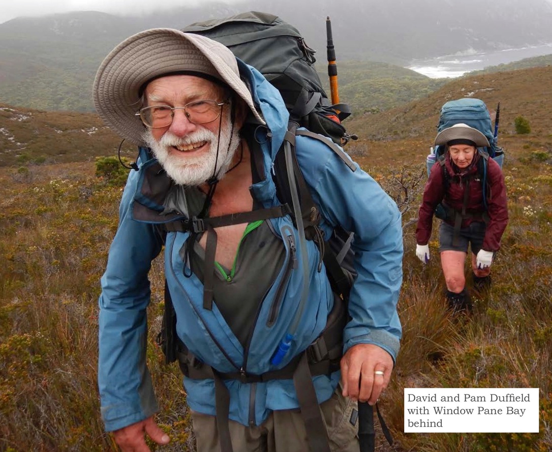
The walk started and finished at the Melaleuca remote airstrip in the South West National Park. On Saturday we received advice from Par Avion (for the flight) that due to forecast windy conditions they had rescheduled our Sunday flight to leave earlier at 8am rather than 2:30pm. Sigh, no relaxed Sunday breakfast at a Hobart cafe!
However, this allowed us to be a day ahead of schedule, as the original plan had our first night at Melaleuca, but now we would have plenty of time to walk the easy four hours to our first camp at New Harbour on the south coast.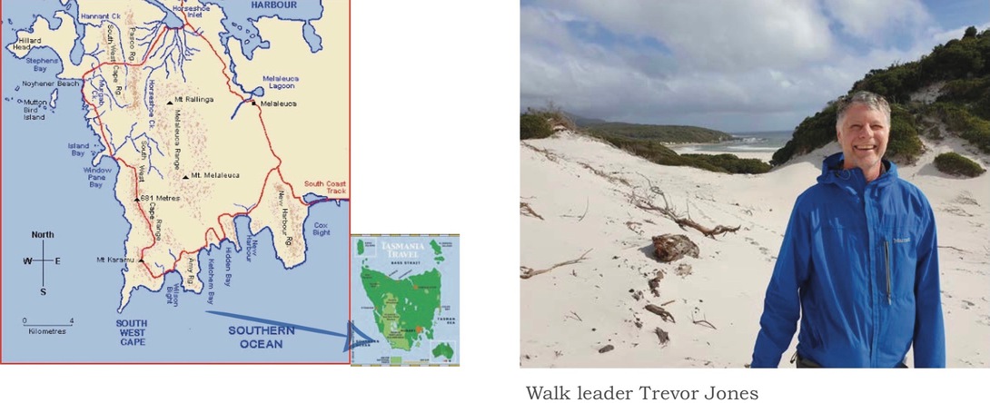
So, on Sunday we made our way to the Cambridge airfield, were weighed in, and paid for stove fuel (to be collected at Melaleuca).
We five plus another person were in one plane, and our luggage spread across planes – four planes in total flying out together. The other person was a Meetup chap leading a diminished group along the south coast track – most had to pull out because of a recent Covid-19 cluster in Brisbane.
Departure was on time at 8am and landed just after 9am. Flying along the coast meant we could see Bruny Island and the south coast cliffs with streamers coming of the waves indicating the blustery conditions. The pilots kept in communications with each other to determine the conditions being experienced. Glad I put on warm clothes as the flight was cold. It was a bumpy ride, happy when we gently touched down. Unloading and reloading quickly, all the pilots were keen to get back in the air before the weather worsened.
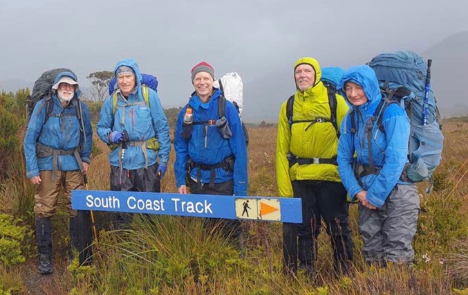
We collected our stove fuel from the pilots, sorted out our packs, left some food containers in the shelter storeroom, and headed off wearing full rain gear and warm layers at 10am. After about six kilometres the turnoff to New Harbour was reached, with no indication other than a light pad off to the right. We had a rest and took off a layer. Up until then it had been easy (occasionally slippery) boardwalks, but now it was the typical eroded path, generally flowing with water due to the constant drizzle. Some gusts in the exposed sections; a few small creeks to step over and a couple of small ascents.
After about three and half hours of hiking we came across the Walkers Registration logbook (with nifty waterproof pages) at New Harbour – the most recent walkers were here January 9th. We waded the shallow creek outlet on the beach and traversed the beach for a while until locating a brackish creek, with a sheltered and spacious camping area. All the camp sites we used along the coast were in the sheltered forest edge next to the beach, all with a fresh water creek flowing nearby. There are no facilities – any ad hoc “seats” or “tables” at the camping locations have been made from flotsam and jetsam.
We were all very damp and cold, so all disappeared into our tents for the rest of the day and night, looking for as many warm dry clothes to put on as we had. A common entertainment for us when snuggled into the tents was watching the occasional leech trying to get through the inner (and of course making sure none entered with you).
The next morning‘s weather at New Harbour was still drizzling rain and gusty, with the ocean roaring nearby. We found out later that there was 20mm of rain at the airstrip today.
After breakfast in our tents (or outside in wet gear), we headed off after donning our damp clothes from yesterday. About two and half hours later we arrived at Hidden Bay, giving up on the idea of the side trip to Mount Melaleuca due to the poor weather. The track was good with a lot of work by Parks. From New Harbour it is through rainforest then to ridges exposed to the elements. The Hidden Bay campsite is not so nice or as large as New Harbour, although Hidden Bay has a nice beach and a large tannin-stained creek flowing well.
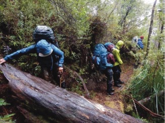
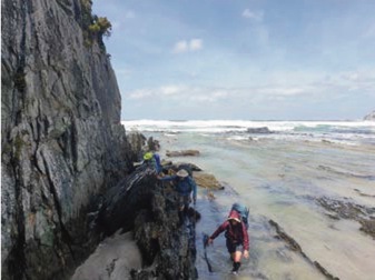
Obsticle-trail between New Harbour and Ketchem
We continued on the improved track that goes from Hidden Bay to Ketchem Bay; great views on this section looking back to Hidden Bay and later to Ketchem Bay. It is very exposed to weather – we were constantly buffeted trying to keep balance. Overall today there was not much mud due to Parks improvements – mostly walking on white rubble, except within the pretty rainforest section after (I think) New Harbour, where some care was required on the narrow “ledge” track and around the tree obstacles. Overall a fairly easy walk where “navigation” is not required.
Looking back to Ketchem Bay
The Hidden Bay to Ketchem section was too exposed to stop for lunch, so we delayed lunch until setting up camp at Ketchem Bay. A mother and daughter came in from Wilson Bight just after dropping our packs at Ketchem – they had spent yesterday in their tent due to the rain. The weather calmed very occasionally after our arrival at Ketchem, but overall, we spent the rest of the Monday in our tents.
The next morning (our third day), John was awake about 6:30 am and saw a rogue wave come up to the edge of the camp – this was due to the high tide and the blustery conditions. The wave covered the sandy sitting area just a few metres away. He was getting ready to do a hasty pack-up, but the water did not reach that level again. Possibly Mal was at a greater risk being slightly lower in the camping area.
Anyway, the weather had cleared, though still blustery, and departure was at a relaxed 9am as it was to be a short day. An easy ascent up the track through the forest and soon we stopped at a creek with a “wash down station” (scrubbing brushes and creek water) to limit the spread of phytophera, for those heading west (like us). We then ascended through relatively open forest on an obvious track. Some sections of the track were almost overgrown, so pushing scrub out of the way was required at times, but not much mud to deal with. Overall, this section of the track has been less maintained than up to Ketchem Bay. The track meandered near the cliffs at times, so gave us some limited coastal views through the trees.
Eventually the track opened to flowering scrub with views of Wilson Bight, and followed by a steep straight forest descent to the beach. But the real challenge then comes to get around the rocky headlands at sea level.
Timing the waves at Wilsons Bight
The tide had been receding since we left camp two and a half hours ago, but we still had challenges getting around the rocky headlands at Wilson Bight (there are two sections that I recall). Much careful clambering as far from waves as possible and watching the timing of the waves got us all around okay, but not completely dry!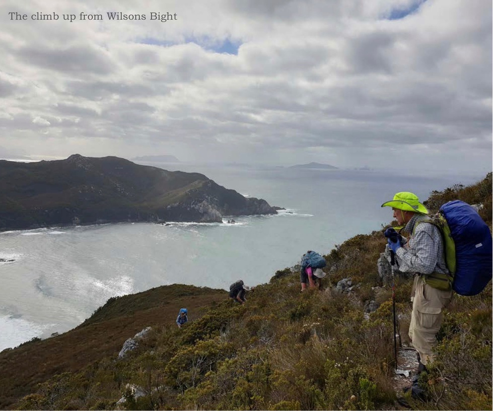
Just before the Wilson Bight camp we passed a small waterfall (source of drinking water) and heaved up the wooden steps to the campground – which takes maybe five tents at the most, however it is sheltered and grassy.
At the camp, the sun was out, and we hung out our wet gear to dry. It was also nice finally eating in the sun together rather than solo in our tents out of the rain. It was a relaxing afternoon exploring the beach area, snoozing, reading and eating.
On the way off Wilson Bight on our fourth day, there was a dead seal tangled in ropes near the entrance to the forest and a live seal further away. The track started with a very steep but short (25 minutes) climb up from the beach through rain forest (rope in place). Some more ascending then the track followed the top of the South West Cape Range so is largely just grasses, no significant scrub, but still much easier walking on a pad than not.
Chapman writes it is a six to nine hour day for the traverse from Wilson Bight to Window Pane Bay, so we took twelve. Some time was invested in hunting for the pad (or just saying, darn, let’s just get across to that ridge, it’s bound to have a pad), as well as taking a steady pace to keep the group together. Finding the pad in poor visibility would be an issue. On a fine day, you may still need to hunt around for it, and use navigation skills to just aim for where you expect the track to be.
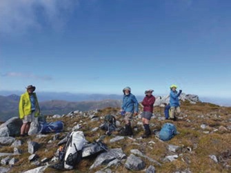
The highest point on SW Cape Range
The day included a couple of notable high points – Mount Karamu and later (at 4pm) the highest point on South West Cape Range. The weather was clear, providing great views along the coast and across to the jagged outline of the Western Arthurs. The only water we found was collected from a tiny tarn – it was novel not having tannin stained water for a change. From the range we could see the peninsular of the South West Cape, but we just waved to it. Later was spotted a pair, I believe, of Tasmanian Purplestars – Isophysis tasmanica and as well the group was watched over by a scattering of white quartz “megalithic” rocks brilliant in the afternoon sun as we started the long slow meandering descent off the range.
The exit to the beach at Window Pane Bay is down a very steep sand “cliff” assisted by a long rope in place. The forest camp requires crossing a rocky bottomed creek twice, so we ended the day again with wet boots and socks etc. We were all very tired by the 8pm arrival but able to setup
camp, then sit around and have dinner before complete darkness.
What is the best thing after a 12 hour walking day? Well chocolate for sure, but what else? A rest day of course! So day five was just that and fortunately a fine day at a very nice campsite – best so far, except for having to cross the slippery rocky creek to the beach. The author did some clothes rinsing and body rinsing, walked to the more sheltered far south west end of the beach for a swim, and Trevor went exploring and the others did similar housekeeping and relaxing activities. Some catlike like creature was lurking near the campsite at dinner time, but was too hard to see clearly.
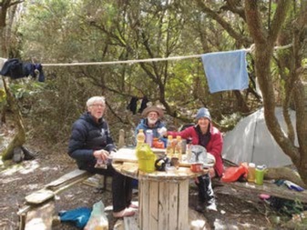
Alfresco dining at Nohenyer Beach
After a nice day at lovely Window Pane Bay it was off for a five hour trek to lovely Noyhener Beach for our sixth day out. Overnight had been overcast and warm and so was the morning sitting around at the agreed breakfast area. But it was cold on the exposed hills and ridges. A relatively easy walk for most of it varying as usual between open scrubland pad, and the melaleuca forests with leaf litter covered pads down to and up from rainforest creek sections.
The pad was easy to follow except on one open hillside (but found quickly continuing straight on), the other was about half a kilometre from the rocky point just before descending to the coast near Noyhener – it appears to be a track junction – the way we went was taped, but through fallen tree obstacles, but came easily to the steep jagged rocks running into the water. The other pad (to the right) we speculated continued through the forest and came out onto the beach further on avoiding the coastal rocks – this turns out to be the case.
We then faced the challenge of clambering on the jagged and a slippery rocks, sometimes timing the waves to move on – at one point we had to climb back up and descend again to the ocean level as it was all water and no rocks at that Anyway, after some time we all got around with only John taking a dunking when exploring ahead for us for a route.
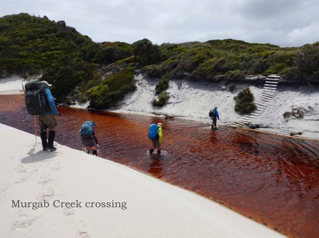 The forest at Noyhener Beach has two sheltered campsites, and grows to the edge of a high sand bank on Murgab Creek, access is a short wade across the sandy bottomed shallow creek and up a chain and wooden ladder.
The weather had brought rain part way through the walk today, but the sun came out just as we left the rocks and onto the beach. The Noyhener/Murgab camp is nice and sheltered. There is a big “table” made of a large wooden cable bobbin with ad hoc bench seats in the middle of the open area – very convenient. There is a second camping area further into the forest, with a steep bank down to the creek for water. There is another Walker’s logbook here recording that recently some day trippers visited from Spain Bay. Trevor and Mal explored the sand dunes and walked west to the rocky point but the tide prevented further progress – jokingly, Mal discouraged Trevor from swimming out to Sugarloaf Rock a mere 4km away, but looks much closer! The group finished the day with a relaxed dinner sitting around the cable table.
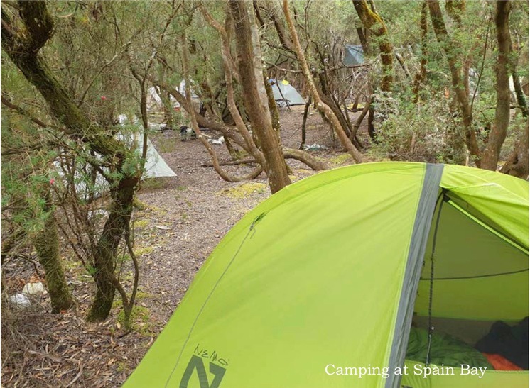
The walk plan included a night at Spain Bay. The following day, Trevor, John and Mal continued on to there, while Pam and David settled in at Noyhener for our return.
 We found an easy route across the sand at the back of the north headland, taking only about fifteen minutes to cross over the headland to Stephens Bay and coming out at the large aboriginal midden complex beside a flowing soak. A few photos were taken at the midden – no surprise there would be a dependable water source there – it looks like a spring feed outlet. We then walked north along the long beach at Stephens Bay (the middens full of abalone shells etc continue for up to half a kilometre) and stopped for a rest at the steps into the forest for the final track to Spain Bay. A creek flows there, and we filled bottles again. The track from there is easy to follow across low heath but it has some muddy sections, taking about 30 minutes to cross to Spain Bay. The bay has a lovely (again) long beach with narrow line of solid forest along the edge.
There were already some tents in the camp site. We three set up tents, had lunch, got water, and rested. After resting we set off on a 4km return walk east along the bay and did scrub exploration to the top of a hill there. Note to readers: I have decided on the phrase “scrub exploration” rather than “bush bashing”, pass it on!
Later a volunteer group of four people returned to camp – they are removing marram grass, and (I think) sea spurge. They have been doing volunteer work for twenty years. This time they were helicoptered into Spain Bay landing on the beach and will spend ten days in the SW Cape area gradually walking back to Melaleuca the way we have come. Later as a reminder to be careful with food, a bandicoot that was not overly concerned about us, went sniffing around the tents looking for an easy meal.
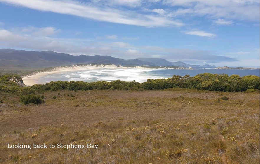
The following day (our eighth) Trevor proposed a morning walk (4.3 km return) to Sunset Hill for some views. We again went past the little headland to the northern beach and then scrub explored up the south end of the Sunset Hill ridge into the mist. We took some photos but waited awhile and the mist cleared to a sunny day with great views of Spain Bay, the next door Hannant Inlet and the entrance to Bathurst Harbour, and a few islands. It was a nice return walk at low tide back along the beaches, and we left Trevor to have a short swim or a swim without shorts – only he knows.
 We packed up camp and next encountered the volunteer group who had moved on and dropped packs at the midden/ soak and were exploring the headland coast between Stephens Bay and Noyhener Beach. We arrived back at the Noyhener camp mid-afternoon with Pam and David waiting at the cable table. Later the volunteers arrived and set up at the second camp which was further into the forest.
From Noyhener Beach the route is about 13km to Horseshoe Inlet, just next to the Port Davey track. Sadly, you have to cross both the South West Cape Range and the Pasco Range! So, we got away early expecting a longish day, putting on shoes, socks and gators after crossing the creek to the beach – why start wet! The exit track is up the dune beside the creek.
We managed to lose the pad not long after, at the top of a hill, and found a pad after some scrubby descent. As an indication of pad visibility, we lost the pad and came down the South Cape Range on one spur north of the spur with a pad – the up/down pads are very obvious when seen from the other side of the valley but not obvious when on top where they are less eroded. The track up the Pascoe range was equally very visible across the valley while on the South West Cape Range, and not too hard to follow.
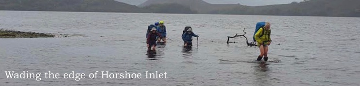 Upon nearing Horseshoe Inlet after about six hours it was hard to locate any pad so we just pushed into and along the forest edge and on the grassy water edges when we could, and in the water at other times. Note that high tide pretty well covers all of the exposed areas between the Horseshoe Inlet low tide edge and the forest of the Horseshoe Inlet – try and get there at low tide if looking to camp or to get onto the Port Davey Track. Trevor got us there at low-tide fortunately (he did well with all the tide planning).
At Horseshoe Creek we stripped down to modesty and as well kept on shoes for the short swim across the creek (shoes in case of sharp branches etc) – we put our clothes into the backpack and the pack into a large garbage bag and tied it shut and this worked well to float the backpacks across, though Trevor had a nifty waterproof backpack that floated nicely on its own. The water was not as cold as any of us expected, nor fortunately was the air as we “dried” and dressed.
We had a lot of trouble finding the camping area at Horsehoe Inlet – in the end we established an ad hoc camping spot I reckon about 100m before we later found what looked like a more used camping area amongst the Melaleuca forest.
Our final hiking day was a very pleasant (not) hike along the muddy Port Davey Track for about four and a half hours including a lunch break. As the Horseshoe Inlet was at high tide, we went through the forest to the nearby larger camping area which had an exit track to the Port Davey track, rather than back to a heavily marked exit we encountered on walking around the inlet.
After several hours, and nearing the airstrip, there is a solid metal foot bridge over Melaleuca Creek– older editions of Chapman’s may not mention it – the creek was very energetic, and we were appreciative of the easy crossing. Upon arrival at Melaleuca we collected our stored food, and set up camp in the trees behind the two hikers huts. The sea water edge of the Melaleuca Lagoon is just down the slope a bit and on a nice day would be an excellent swimming spot – it was very useful for rinsing all the mud off shoes and gaters.
We tried to have a group dinner at the picnic table, but rain interrupted our plans.
Back to civilization on day eleven. We had a scheduled flight out at 10am from Melaleuca, and the weather was much nicer this time. We packed up and waited in the museum for our flight. There we met a woman who was counting the parrots and had just released some, and she (not the birds) was also flying back with us. Just before 10am, two planes flew in with day visitors who were all wearing facemasks, and we were all handed facemasks by the volunteer caretaker – someone had decided both Cambridge and Melaleuca were airports. Along with our luggage, we all went on a twin engine plane taking about an hour in calm but overcast skies. This time we flew inland, to the right of (and lower than) the West Portal of the Western Arthurs and could just glimpse Federation Peak in the distance to the right.
On arrival at Cambridge we made our various ways to Hobart accommodation, hot showers and cleaner clothes, and met again in the evening for a nice dinner down at Salamanica.
The next day, another adventure started for Trevor, Mal and John before flying back to Adelaide – while Pam and David enjoyed the cafes and sights of Hobart – but that is another story.
Group photo at Port Davey Track sign at Melaleuca
A 20 minute video of this trip can be seen at https://www.youtube.com/watch?v=WNDWjeg7TEE
This trip report brought me to this group and I’m a proud full member now. I hope this south west loop is repeated and please include me as a very enthusiastic participator. Jules